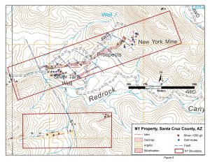
The NY project is composed of 12 unpatented mining claims located on US Forest lands in Santa Cruz County, Arizona about 6 miles northeast of Taylor Ag-Pb-Zn deposit.
Historic work consists of past production of ~30,000 tons from a shaft and 3 levels. Pre averaged between 22 and 45 opt silver, 5 to 10% copper and 0.1 to 0.25 opt gold. Four short core holes (<150 feet each) drilled in the mid-1960’s. Holes were positioned to intersect silver mineralization in veins on the east end of the property and encountered anomalous to mineralized silver over narrow widths. Historic records indicate increasing copper and zinc grades at depth.
Recent work includes 50 surface geochem samples collected from underground and surface and a detailed geologic map with alteration and underground maps compiled from several sources. Samples contain up to 800 g/t silver and 4% combined lead-zinc from surface exposures.
The above work has identified two main areas of mineralization including –
- Silicified and argillized andesite with multiple veins of quartz-barite-calcite from 30 to 110 feet in width along a N70E trend horsetailing on the eastern margin to ~5 feet thick veins.
- Argillized and bleached andesite with chalcedonic veins offset ir sub-parallel some 2000 feet south of the above zone.
The property has a well defined footprint of alteration and mineralization similar to nearby South32’s Taylor CRD hosting 101 million tons @ 10.4% ZnEq.


