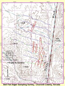
The Bell Flat Project is comprised of 9 unpatented mining claims covering a total of 180 acres located within the Walker Lane trend, Churchill County, Nevada. The property is located approximately 15 miles north of Gabbs, Nevada and 25 miles north of the Paradise Peak mine. This project represents an advanced stage exploration property with no defined resource. Extensive soil and rock sampling, geophysical surveys and drilling have identified several alteration zones along a corridor approximately 3,500 meters in length. Gold and silver occur developed along the contact of jasperoid and argillized Tertiary volcanic rock intermittently along the corridor. The mineralization has been encountered from surface to depths of 160 meters in drilling. Gold values exceed 5.1 g/t in trenching while silver values reach 200 g/t from historic drilling. The mineralized zone is open in all directions. A “Santa Fe type” model is indicated for the project based on the geology and alteration.
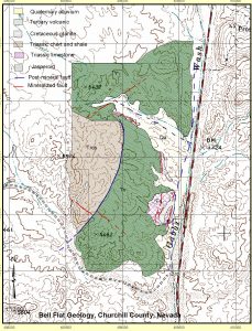
The project area encompasses a northwesterly trending structural zone. The structure cuts Tertiary felsic volcanic rocks and Triassic sediments which are the host rocks at the nearby Santa Fe gold-silver deposits. Alteration as jasperoid follows the contact of the Triassic limestone and Tertiary volcanic rocks. Shallow pits, trenches and drill holes have encountered gold and silver within argillized shale and jasperoid developed along this contact and within a clay altered felsic volcanic. Altered rocks are capped by post-mineral basalt and wind-blown sand.
Historic work in the area was initiated in the early 1900’s when prospectors discovered copper oxides within an exposed granitic sill on the south end of the property. There is no reported production from the property.
Recent exploration includes several holes by Dome exploration in 1985. Nine holes were drilled by Hemlo Gold in 1993. Hemlo also conducted an IP survey resulting in 9 lines on the north half of the property. Hemlo encountered 30 feet grading 1.8 opt silver and combined 4% lead-zinc in jasperoid and 0.014 opt over 60 feet in clay altered Tertiary volcanics. This mineralization remains open in all directions. Over 300 auger soil samples were collected in 2005. The various exploration programs define a corridor of gold and silver mineralization trending northwesterly for over 3,500 meters under alluvial cover to the northwest.
Potential for over 1 million ounces of gold equivalent may exist given the strike length and grades encountered in rock chip sampling and drilling. Additional targets remain untested within the Triassic shale, the main host for the Santa Fe and Chalk Mountain ore deposits.