Lone Ranch, Washington
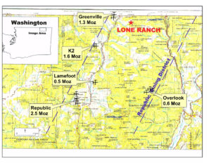
The Lone Ranch Project is located in Ferry County, Washington. There are 73 claims (1460 acres) covering a zone of calc-silicate alteration, skarn and gossan exposed intermittently over a distance of 10,000 meters in length. The mineralization is similar to the nearby Buckhorn skarn deposits mined by Kinross for over 10 years and producing over 1 million ounces of gold at an average grade of 8 g/t.
Altered limestone and phyllite are cut by porphyry dikes. Gold was intersected in drilling st the southerly end of the property. Grades range from 12 g/t over 3 meters to 1 g/t over 43 meters. Quartz-sericite-pyrite alteration is pervasive within certain zones of phyllite and limestone. Drilling in the main area was completed by Cyprus and Kennecott.
Golden Oasis completed a district wide HEM/aeromagnetics survey in 2007 and identified a several large EM anomalies within and adjacent to the property. A follow up drilling campaign of wide spaced holes was carried out in 2008 with drilling of 14 wide spaced and relatively shallow core holes. These holes confirmed the presence of additional gold values in various areas along trend, but have not been followed up.
The strong alteration, surface geochemistry, associated geophysical anomalies, and nearby high grade mineralization mined in the past suggest excellent potential for discovery of additional near-surface gold skarn of reasonable grade.
Although claims are located on US Forest lands, permitting has been easy and quick, accomplished in less than 3 months time. Access is available on existing logging roads which cut through much of the area.